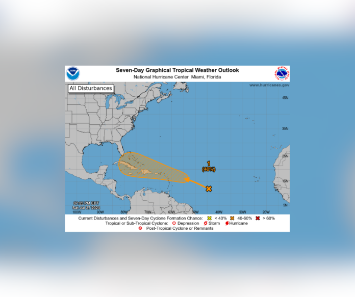
Tropical Weather Outlook Update: Potential Tropical Depression in the Atlantic
NWS National Hurricane Center Miami, FL
8:00 AM EDT, Sunday, July 28, 2024
The National Hurricane Center (NHC) in Miami has issued an updated tropical weather outlook for the North Atlantic, Caribbean Sea, and the Gulf of Mexico. Forecaster Berg reports continued monitoring of an area of disturbed weather over the central tropical Atlantic Ocean.
Key Updates:
- Location and Development:
- The disturbed weather is currently near the Leeward Islands and Greater Antilles.
- It is interacting with an approaching tropical wave and is expected to do so over the next several days.
- Environmental conditions are becoming conducive for development, with the potential for a tropical depression to form by midweek.
- Formation Chances:
- The chance of formation within the next 48 hours remains low at near 0 percent.
- The chance of formation over the next 7 days is medium, at 40 percent.
The system could impact the northern Leeward Islands, Greater Antilles, or the southwestern Atlantic Ocean in the coming days. Residents and maritime interests in these regions are advised to stay informed and prepared for potential tropical storm conditions.
Original Article
Miami, FL (July 27, 2024) – The National Hurricane Center (NHC) in Miami, FL, has issued a tropical weather outlook for the North Atlantic, Caribbean Sea, and the Gulf of Mexico. Forecaster Blake reports that an area of disturbed weather over the central tropical Atlantic Ocean is interacting with an approaching tropical wave. This interaction is expected to continue over the next several days.
Key Points:
- Location and Development:
- The disturbed weather is located near the Lesser and Greater Antilles. Environmental conditions are becoming conducive for development, with a potential tropical depression forming by midweek. The system may affect the northern Leeward Islands, Greater Antilles, or southwestern Atlantic Ocean.
- Formation Chances:
- The chance of formation within the next 48 hours remains low at near 0 percent. The chance of formation over the next 7 days is medium, at 40 percent.
Graphical Outlook:
The accompanying seven-day graphical tropical weather outlook illustrates the system’s potential path and formation probability. The shaded area indicates a 40 percent chance of development within seven days, highlighting the potential threat to the Caribbean and surrounding regions.
Residents in the potential impact zones are advised to monitor updates from the National Hurricane Center and local weather agencies. Preparation for possible tropical storm conditions may be necessary as the situation develops.
Stay Informed:
- For continuous updates, visit the NHC website at www.hurricanes.gov. Follow UrbanCast and involvedinitall.com for updates and alerts.
Souce: NHC


