

")
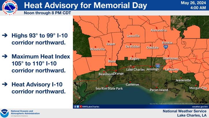
Alexandria, LA (May 26, 2024) – Residents of the Alexandria and Pineville area should prepare for extremely hot weather as a heat advisory has been issued by the National Weather Service. The advisory will be in effect from noon to 8 PM CDT on Memorial Day, Monday, May 27, 2024.

Today’s Weather:
Expect mostly cloudy skies turning sunny by the afternoon with a high near 93 degrees. The heat index will make it feel like 101 degrees, with south winds blowing at 10 to 15 mph and gusts up to 25 mph.
Tonight:
Clouds will increase, with temperatures dropping to a low around 75 degrees. South winds will continue at 5 to 10 mph, with gusts up to 20 mph.
Memorial Day:
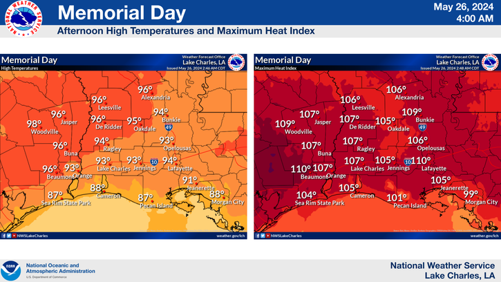
The morning will start with patchy fog before 9 AM, then mostly cloudy skies will gradually clear to sunny with a high near 96 degrees. Heat index values could soar as high as 106 degrees. Winds will be light from the southwest around 5 mph.

Monday Night:
Expect mostly clear skies with patchy fog developing after 5 AM. Temperatures will drop to a low around 71 degrees with calm winds.
Extended Forecast:
- Tuesday: There’s a 20% chance of showers and thunderstorms after 1 PM. Morning fog between 7 AM and 8 AM. Otherwise, mostly sunny with a high near 93 degrees. Light east winds.
- Tuesday Night: Partly cloudy with a low around 70 degrees. Calm winds.
- Wednesday: Scattered showers and thunderstorms with a high near 86 degrees. Light east winds. 30% chance of precipitation.
- Wednesday Night: Partly cloudy with a low around 67 degrees. Calm winds.
- Thursday: Scattered showers and thunderstorms in the afternoon with a high near 87 degrees. 30% chance of precipitation.
- Thursday Night: Partly cloudy with a low around 67 degrees.
- Friday: 30% chance of showers and thunderstorms. Partly sunny with a high near 87 degrees.
- Friday Night: Mostly cloudy with a low around 70 degrees.
- Saturday: Scattered showers and thunderstorms with a high near 87 degrees. 30% chance of precipitation.

Heat Advisory Details:
The advisory covers portions of central, southwest, and west central Louisiana and southeast Texas. Heat index values are expected to range between 108 and 110 degrees, posing a risk of heat-related illnesses.
Precautionary Measures:
- Stay Hydrated: Drink plenty of fluids.
- Stay Cool: Stay in air-conditioned areas and avoid direct sunlight.
- Check on Vulnerable Individuals: Ensure that relatives and neighbors, especially the elderly and those with health conditions, are coping well with the heat.
- Limit Outdoor Activities: Reschedule strenuous activities to early morning or evening. If you must be outside, take frequent breaks in shaded or air-conditioned environments and wear light, loose-fitting clothing.
- Know the Signs: Be aware of the symptoms of heat exhaustion and heat stroke, and seek immediate medical attention if needed.
Residents are urged to take these precautions seriously to avoid heat-related health issues during this period of extreme temperatures. Stay safe and stay cool.
Note: The heat advisory issued by the National Weather Service covers several parishes in Louisiana, including Vernon, Rapides, Avoyelles, Beauregard, Allen, Evangeline, St. Landry, Lafayette, and Upper St. Martin. In Texas, the advisory includes the counties of Tyler, Hardin, Northern Jasper, Northern Newton, Southern Jasper, and Southern Newton.
Source: NWS Lake Charles


)