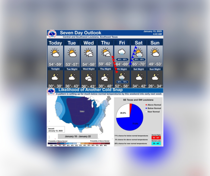
Central Louisiana faces a potential cold blast this weekend, bringing much-below-normal temperatures and significant changes to the region. The National Weather Service predicts this Arctic front will arrive between January 18 and 22, driving temperatures well below seasonal averages.
This week begins with mild conditions. Monday through Thursday will see daytime highs ranging from 54°F to 62°F, with chilly nighttime lows dipping into the mid-30s to low 40s. Skies will stay partly cloudy through midweek, providing mostly dry conditions.
By Friday, rain chances increase to 40-60% as a warm front moves in, lifting highs to the mid-60s. Overnight, rain intensifies with a 50-70% chance of showers as a strong cold front sweeps through. Saturday’s highs will range from 65°F to 70°F before the front moves in during the evening, bringing significantly colder air. By Saturday night, temperatures will plummet into the mid-30s, with Sunday highs struggling to reach the low 50s.
The potential cold blast in central Louisiana will take full effect by Sunday night, with lows falling into the mid-20s. These subfreezing temperatures could last through early next week, impacting daily routines and outdoor activities.
Residents are urged to prepare for this upcoming cold spell. Winterize homes and vehicles, protect outdoor pets and plants, and stay informed through updated forecasts. With a 71% chance of below-normal temperatures for the region, the cold blast could bring the coldest conditions of the season.
Stay tuned to UrbanCast / InvolvedInItAll.com for more updates as this Arctic system approaches. Make plans now to ensure safety and comfort as temperatures drop sharply.
Previous Weather Article: Severe Weather Threat in Central Louisiana on December 28, 2024


