

 - Weather Advisory: Heat Wave Sweeps Across the Region (NWS-LC)")
The National Weather Service (NWS) has issued a Heat Advisory, effective today from 11:00 AM CDT until 7:00 PM CDT. This advisory affects the following parishes and counties: Vernon, Rapides, Avoyelles, St. Landry, Lafayette, Upper St. Martin, Lower St. Martin, Upper Vermilion, Upper Iberia, Upper St. Mary, Southern Acadia, Lower Vermilion, Lower Iberia, Lower St. Mary, Tyler, Hardin, Northern Jasper, and Northern Newton.

Today’s Forecast:
Residents should brace for extreme heat with temperatures soaring to near 98 degrees. The heat index is expected to reach as high as 109, making it crucial to take necessary precautions to stay safe. There is a slight chance (20%) of showers and thunderstorms after 1 PM. Winds will be calm, becoming southerly around 5 mph in the afternoon.
Tonight:
The evening will bring partly cloudy skies with a low around 76 degrees. Expect a southwest wind around 5 mph.
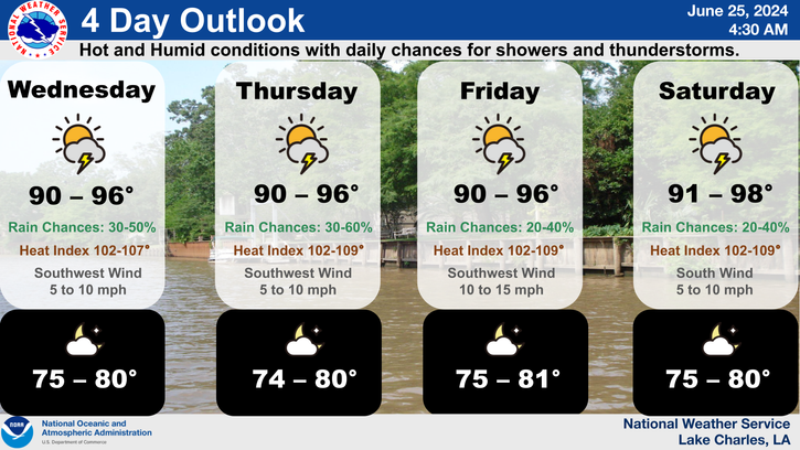
Wednesday:
The heat continues, though slightly reduced, with a high near 96 degrees and a 40% chance of afternoon showers and thunderstorms. The heat index will still be significant, potentially reaching 105. Winds will remain southwest at 5 mph.
Wednesday Night:
Showers and thunderstorms are possible (30%) under partly cloudy skies, with a low around 76 degrees. Winds will stay at 5 mph from the southwest.

Thursday:
There is a higher chance (50%) of showers and thunderstorms. The high will be near 94 degrees, with calm winds becoming westerly around 5 mph.
Thursday Night:
Expect mostly clear skies with a low around 74 degrees. Winds will be from the south at 5 mph, becoming calm overnight.
Friday:
Mostly sunny with a high near 96 degrees and a slight chance (20%) of afternoon showers and thunderstorms. Winds will be calm, shifting to the south at 5 mph in the morning.
Friday Night:
Clear skies will prevail with a low around 75 degrees and south winds at 5 to 10 mph.
Saturday:
Hot and sunny conditions return with a high near 98 degrees and a 20% chance of afternoon showers and thunderstorms. Winds will be calm, turning southerly at 5 mph in the morning.

Saturday Night:
Expect mostly clear skies and a low around 75 degrees.
Sunday:
A high of 99 degrees is forecasted with a 30% chance of showers and thunderstorms. Mostly sunny and hot conditions will continue.
Sunday Night:
Partly cloudy with a low around 76 degrees.
Monday:
The heat wave persists with a high near 99 degrees and a 20% chance of showers and thunderstorms. Sunny and hot weather will dominate.
Safety Tips:
- Stay hydrated and drink plenty of water.
- Avoid strenuous outdoor activities during peak heat hours.
- Check on vulnerable family members and neighbors.
- Use air conditioning and stay in cool places.
- Wear light, loose-fitting clothing.
Please take this Heat Advisory seriously and take the necessary steps to protect yourself and your loved ones from the extreme heat. Stay tuned to local weather updates for any changes in the forecast.


 - Weather Advisory: Heat Wave Sweeps Across the Region)