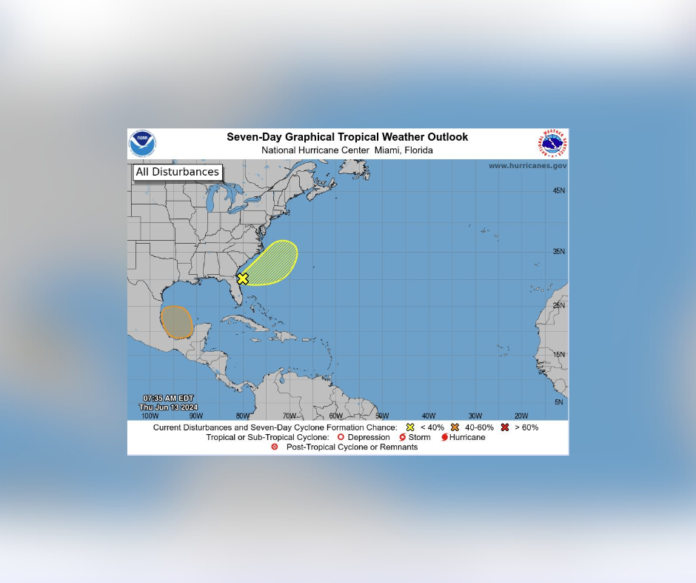
Miami, FL – June 14, 2024 – The National Hurricane Center (NHC) is monitoring two areas in the Atlantic basin for potential tropical development.
Off the Southeast Coast:
- An elongated area of low pressure is currently located offshore the coast of Florida, producing disorganized showers and thunderstorms.
- Despite strong upper-level winds, some gradual development is possible as the system moves northeastward over the next couple of days.
- Regardless of development, heavy rainfall is expected to continue across portions of the Florida peninsula through late this week.
- This system has a low (20%) chance of formation over the next 48 hours and remains at 20% over the next seven days.
Southwestern Gulf of Mexico:
- A broad area of low pressure is expected to form over the southwestern Gulf of Mexico late this weekend or early next week.
- Environmental conditions appear favorable for gradual development, with the potential for a tropical depression to form during the early or middle of next week as the system moves slowly westward or west-northwestward.
- This area has a near zero chance of formation over the next 48 hours, but a medium (40%) chance of development over the next seven days.
NHC Advises Staying Vigilant
The NHC urges residents in the southeastern United States and the southwestern Gulf of Mexico to closely monitor weather updates for any potential impacts from these systems.
Stay Informed:
- For the latest tropical weather information, please visit the NHC website at hurricanes.gov.
- For the latest marine forecast, please visit hurricanes.gov/marine.
The NHC will continue to monitor these areas and provide updates as necessary.


